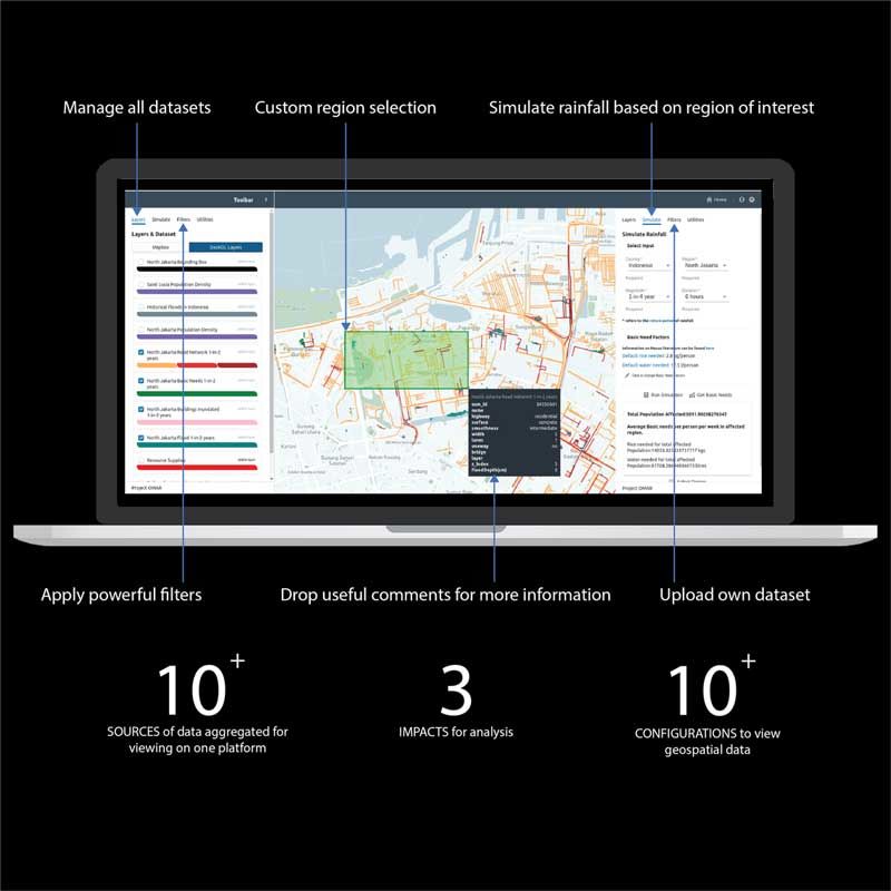
CAPSTONE DESIGN SHOWCASE 2020
GOING VIRTUAL
-
DAYS
-
HOURS
-
MINUTES
-
SECONDS
COMING SOON


Team members
Lam Ying Sheng (ESD), Voon Soo Jun (ESD), See Yi Jie (ISTD), Khor Zile @ Khor Zi Long (ISTD), Jeremia Juanputra (ESD), Nashita Abd Tipusultan Guntaguli (ISTD)
Instructors:
Writing Instructors:
Nurul Wahidah Binte Mohd Tambee
Teaching Assistant:
 Lam Ying Sheng
Engineering Systems and Design
Lam Ying Sheng
Engineering Systems and Design
 Voon Soo Jun
Engineering Systems and Design
Voon Soo Jun
Engineering Systems and Design
 See Yi Jie
Information Systems Technology and Design
See Yi Jie
Information Systems Technology and Design
 Khor Zile @ Khor Zi Long
Information Systems Technology and Design
Khor Zile @ Khor Zi Long
Information Systems Technology and Design
 Jeremia Juanputra
Engineering Systems and Design
Jeremia Juanputra
Engineering Systems and Design
 Nashita Abd Tipusultan Guntaguli
Information Systems Technology and Design
Nashita Abd Tipusultan Guntaguli
Information Systems Technology and Design
Lam Ying Sheng
Engineering Systems and Design
Voon Soo Jun
Engineering Systems and Design
See Yi Jie
Information Systems Technology and Design
Khor Zile @ Khor Zi Long
Information Systems Technology and Design
Jeremia Juanputra
Engineering Systems and Design
Nashita Abd Tipusultan Guntaguli
Information Systems Technology and Design